Copernicus/Sentinels data processing
The Australian research community has now access to the full set of observations from the new European Copernicus satellite missions, the “Sentinels”. This is possible through “Copernicus Australia”, which is a regional data hub supporting all potential users in our region.
We have taken advantage of this priviledged access to start developing tools for processing observations from the Sentinel3-OLCI and Sentinel2-MSI instruments in particular.
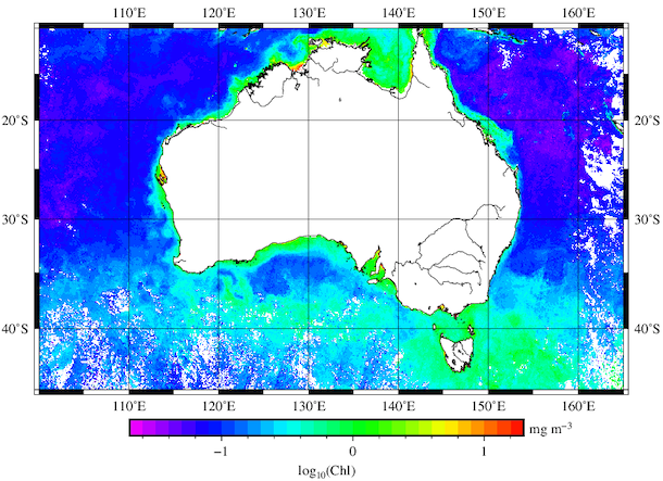
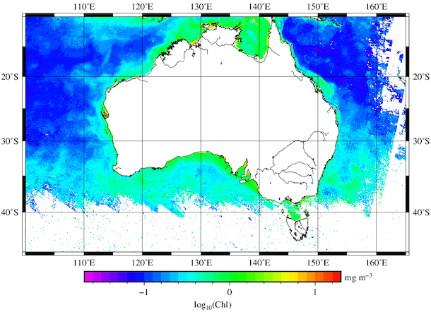
This capability is illustrated below with maps of the phytoplankton chlorophyll concentration around Australia, from the OLCI instrument. These maps display the average concentration for April (top) and June (bottom) 2019, and were obtained through processing of about billions pixels using Pawsey computing resources and the Australia “Copernicus data Hub”.
This is work in progress (some improvements needed for cloud masking), and you can contact us if you have questions about this development

Algorithms applied to generate this product
- Atmospheric corrections: Antoine, D. and A. Morel (1999). A multiple scattering algorithm for atmospheric correction of remotely-sensed ocean colour (MERIS instrument) : principle and implementation for atmospheres carrying various aerosols including absorbing ones, International Journal of Remote Sensing, 20, 1875-1916.
- Pigment retrieval: Morel, A., Huot, Y., Gentili, B., Werdell, P.J., Hooker, S.B. and B.A. Franz (2007). Examining the consistency of products derived from various ocean color sensors in open ocean (Case 1) waters in the perspective of a multi-sensor approach. Remote Sensing of Environment, 111, 69-88.
- Level3 generation: IOCCG (2004). Guide to the Creation and Use of Ocean-Colour, Level-3, Binned Data Products. Antoine, D. (ed.), Reports of the International Ocean-Colour Coordinating Group, No. 4, IOCCG, Dartmouth, Canada.
